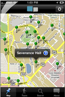
dxy app brings historical archives to present day on smartphones

DXY Solutions is working with historical societies around the country to put historical information, pictures and maps on iOS and Android systems for a complete and informative history while roaming the city.
“We started this about a year and a half ago with Cleveland State and Epstein Design Partners,” explains DXY’s Dan Young. “We use iOS and Android to connect people who are out and about with historical information."
Known as Curatescapes, the free apps allow for easy access to the troves of historical information collected by these organizations. “We’re one of the first platforms in the world where you can walk down the street and say, Wow. I didn’t know that. Now you not only have historical neighborhoods, you can hear interviews with people and see pictures.”
The Cleveland app has been available for about a year with Cleveland Historical. Young is in the process of rolling out similar apps with five historical societies, including Medina and Geauga counties. Outside of Ohio, Young has launched apps for Spokane, Washington Historical and is about to launch apps in New Orleans and Baltimore.
“The grand vision is: Say you’re taking a cross-country trip and you want to drive Louis and Clark’s trail,” Young says. “You can actually connect to data from our different historical societies.”
Young’s future plans will allow users and organizations to upload their own information to the tours. “In the future we will allow people from the community to upload their own content and comment on their own version of historical places,” says Young. “And historians will go through it and make sure it makes sense.”
Source: Dan Young
Writer: Karin Connelly

